Bottom Mapping
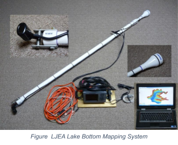
In 2011, with the aid of a grant from the Rostan Family Foundation, LJEA purchased equipment and began mapping the bottom and sediment deposits in Lake James. The original goal of the Bottom Mapping Program was to monitor the bottom as it changes over time:
- Monitoring sediment buildup in various areas of the Lake.
- Observing how the Catawba River channel changes over time.
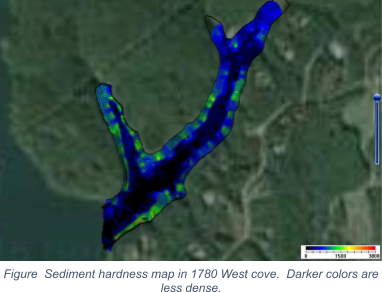
- Mapping the bottom hardness in river deltas (an indication of the type and age of sediments).
The mapping program was a part of an overall erosion and silt reduction effort, an effort that continues to date.
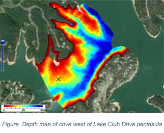
The program never intended to map the entire lake but focused on areas of particular interest like the five river deltas: Linville, North Fork, Catawba, Paddy's Creek, and Black Bear Cove. In addition, LJEA wanted to have the capacity to map coves where there might be problems such as new developments with inadequate erosion and sediment controls. Among the work objectives were:
- Establishing baseline results for various sites, including a pilot test of what changes after a storm, and
- Using full pond elevation as a reference for all depth measurements that would be comparable over years of observation.
Since 2011, LJEA has used the bottom mapping program as an educational tool, helping people understand the dynamics and impacts of erosion and lake sedimentation. Seven years of data have been collected, annually mapping the river deltas to determine the magnitude of change. The program has helped LJEA work with land owners and others interested in the health of our streams and the lake to better understand stormwater management, help stabilize existing erosion sites, and prevent future erosion before it washes away people's land, destroys fish habitat, and gradually fills in the lake.
Due to the loss of a key volunteer, the bottom mapping program was suspended in 2019. LJEA wants to refine the objectives of the program and restart it in 2020 with a focus on assisting lake front property owners and helping everyone understand the impacts of development and erosion control on their lands. Please let us know if you are interested in assisting us.