Biological Survey
Summary
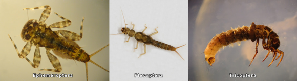
An important means of measuring the ecological health of a waterbody is to assess the health and diversity of the organisms that live in it. During January, February, and April of 2018, LJEA volunteers and faculty and students of UNC-Asheville and Appalachian State University investigated a total of 19 sites in the Catawba and Linville watersheds: 15 sites in the Catawba watershed and streams draining directly to Lake James and 4 sites in the Linville watershed. Multiple survey activities were conducted at each site including the collection, sorting, and identification of benthic macroinvertebrates living in the stream. The data collected suggest that winter samples from the Upper Catawba River, its major tributaries, and the Linville watershed are healthy. Four collection locations had a relatively high number of pollutant intolerant taxa (a good indication of stream health). These sites include the Linville River above NC Hwy 126, Curtis Creek above US 70, Mill Creek near the Andrews Geyser and Mackey’s Creek below US 70. As water pollution or habitat loss increases scientists would expect to collect fewer intolerant taxa. Collection locations that have fewer intolerant taxa (and higher biotic index values) suggest potential pollution or habitat degradation and the need for further investigation. Sites in this assessment which indicated slight to moderate degradation include White Creek above NC 126, North Fork Catawba River at Cannon Road, North Fork Upper at North Cove School Road, North Fork Lower at Pitts Station Road, and Crooked Creek at McHone Road. These five locations indicate that water pollution or habitat loss (possibly due to sedimentation) are negatively affecting the biological integrity of these streams.
Winter surveys often result in ‘best case’ conditions. Generally, streams in the winter are not stressed because of low dissolved oxygen or high-water temperatures and therefore intolerant taxa can dominate. LJEA intends to repeat the surveys in the fall of 2018, during ‘poorer’ conditions, to note differences in the fauna and to assess sources of pollution.
At each survey site, the North Carolina Department of Environmental Quality (DEQ) Habitat Assessment procedure for rivers and streams was completed. None of the surveyed sites exhibited extreme habitat degradation but several of the sites were impacted by sedimentation, degraded riparian zones (the land immediately adjacent to a waterbody), and nearby roadways or development.